

Ontario's independent and community-driven weather organization. Providing context to severe weather since 2013. Download our app: https://xitter.twitterapi.xyz/t.co/HIGhpa8g3m
Ontario, Canada
Joined April 2013
- Tweets47K
- Following917
- Followers76.1K
- Likes2K






#ONStorm #ONwx ❄️ A Little Snow Is on the Way for Parts of Southern Ontario Thursday
The snow brushes might still come in handy, but this isn’t shaping up to be a widespread Southern Ontario snowfall event! 👀
When we shared our model update the other night, there was still some disagreement over where the moisture would track. Some models showed a swath of accumulating snow reaching into Eastern Ontario, while others kept the bulk of the precipitation farther south and east.
Since then, the data has shifted toward that more southerly track. As a result, most of Eastern Ontario, including the Ottawa Valley, is no longer expected to see accumulating snow from this system.
A few flurries are still possible outside the highlighted zone, but they aren’t expected to add up to much.
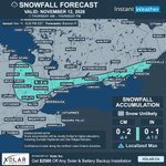
Rain will move through parts of Southern Ontario tonight into Thursday morning. As colder air moves in, some of that rain could change over to wet snow during the day, particularly across the higher elevations northwest of the GTA and into parts of Central Ontario.
Most areas in the highlighted zone could see around 0 to 2 cm, with up to 4 cm possible in a few localized spots. This includes areas around Collingwood, Mount Forest and Orangeville, along with a narrow zone extending eastward near the northern Lake Ontario shoreline and toward Brockville.
The timing of the change from rain to snow and the temperature will make a big difference, especially closer to Lake Ontario. Some places may see wet flakes but little or no accumulation, while the higher elevations have a better chance of seeing snow stick.
For much of Southwestern Ontario, the GTA and Niagara, rain is still expected to be the main story, although a few wet flakes can’t be ruled out as colder air arrives.
🌬️ Lake-effect snow will be the next chapter
Behind the system, colder air moving over the Great Lakes could bring lake-effect rain and snow showers to areas southeast of Lake Huron and Georgian Bay from Thursday night into Saturday morning.
These showers will be localized, so some communities could pick up a few centimetres while others nearby see very little. Inland areas and higher elevations will have the best chance of seeing snow stick.
We’ll take a closer look at where the bands could set up as we get closer.
This map shows the snow expected from Thursday’s system only. Any lake-effect accumulation afterward would be on top of what’s shown here.
Did you find your snow brush yet, or are you still pretending winter isn’t coming? 😏
- Brennen

5:22p SPECIAL WEATHER STATEMENT ISSUED by Environment Canada
(Locations listed below description)
Winter weather travel statement in effect.
What:
Local snowfall amounts near 5 cm along with hazardous travel conditions.
Where:
Along the Highway 101 and Highway 651 corridors to the west of Chapleau and east of Wawa.
Areas south of and including Chapleau along and west of the Highway 129 corridor.
When:
Snow is expected to end later this evening.
Motorists should expect hazardous winter driving conditions and adjust travel plans accordingly. Travel may be hazardous due to sudden changes in the weather. Surfaces such as highways, roads, walkways and parking lots may become difficult to navigate due to accumulating snow.
Prepare for quickly changing and deteriorating travel conditions.
For road conditions and other traveller information from the Ministry of Transportation, visit or call 5-1-1.
Please continue to monitor alerts and forecasts issued by Environment Canada. To report severe weather, send an email to ONstorm@ec.gc.ca or post reports on social media using #ONStorm.
NEW:
- Agawa
- Chapleau
- Lake Superior Park
- Missinaibi Lake

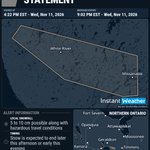
4:22p SPECIAL WEATHER STATEMENT UPDATED by Environment Canada
(Locations listed below description)
Winter weather travel statement in effect.
What:
Local snowfall amounts of 5 to 10 cm possible along with hazardous travel conditions.
Where:
Along the Highway 17 corridor from Dubreuiville Corners to White River and along the Highway 519 corridor to the town of Dubreuiville.
When:
Snow is expected to end later this afternoon or early this evening.
Motorists should expect hazardous winter driving conditions and adjust travel plans accordingly. Travel may be hazardous due to sudden changes in the weather.
Slow down driving in slippery conditions. Watch for taillights ahead and maintain a safe following distance.
For road conditions and other traveller information from the Ministry of Transportation, visit or call 5-1-1.
Please continue to monitor alerts and forecasts issued by Environment Canada. To report severe weather, send an email to ONstorm@ec.gc.ca or post reports on social media using #ONStorm.
UPDATED:
- Dubreuilville
- White River

12:24p SPECIAL WEATHER STATEMENT ISSUED by Environment Canada
(Locations listed below description)
Winter weather travel statement in effect.
What:
Local snowfall amounts near 5 cm possible along with hazardous travel conditions.
Where:
Along the Highway 17 corridor from Dubreuiville Corners to White River and along the Highway 519 corridor to the town of Dubreuiville.
When:
Snow is expected to end later this afternoon.
Motorists should expect hazardous winter driving conditions and adjust travel plans accordingly. Travel may be hazardous due to sudden changes in the weather.
Slow down driving in slippery conditions. Watch for taillights ahead and maintain a safe following distance.
For road conditions and other traveller information from the Ministry of Transportation, visit or call 5-1-1.
Please continue to monitor alerts and forecasts issued by Environment Canada. To report severe weather, send an email to ONstorm@ec.gc.ca or post reports on social media using #ONStorm.
NEW:
- Dubreuilville
- White River

9:49a FOG ADVISORY (YELLOW LEVEL) ENDED by Environment Canada
(Locations listed below description)
Poor visibility in fog is no longer expected.
ENDED:
- Arthur
- Cambridge
- Erin
- Guelph
- Kitchener
- Mount Forest
- Northern Wellington County
- Region of Waterloo
- Southern Wellington County
- Waterloo

6:19a FOG ADVISORY (YELLOW LEVEL) UPDATED by Environment Canada
(Locations listed below description)
Near-zero visibility in fog continues over some areas.
Fog patches will dissipate later this morning.
Visibility will likely be suddenly reduced at times.
Be prepared for areas of near-zero visibility and allow extra time to reach your destination.
Please continue to monitor alerts and forecasts issued by Environment Canada. To report severe weather, send an email to ONstorm@ec.gc.ca or post reports on social media using #ONStorm.
UPDATED:
- Arthur
- Cambridge
- Erin
- Guelph
- Kitchener
- Mount Forest
- Northern Wellington County
- Region of Waterloo
- Southern Wellington County
- Waterloo

6:08a FOG ADVISORY (YELLOW LEVEL) ISSUED by Environment Canada
(Locations listed below description)
Near-zero visibility in fog continues over some areas.
Fog patches will dissipate later this morning.
Visibility will likely be suddenly reduced at times.
Be prepared for areas of near-zero visibility and allow extra time to reach your destination.
Please continue to monitor alerts and forecasts issued by Environment Canada. To report severe weather, send an email to ONstorm@ec.gc.ca or post reports on social media using #ONStorm.
NEW:
- Cambridge
- Kitchener
- Region of Waterloo
- Waterloo

#ONStorm #ONwx 🌡️ November, Are You Feeling Okay? 👀
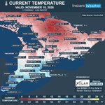
It’s a mild one across Southern Ontario this afternoon! Windsor is sitting at 19°C, Sarnia has reached 17°C, and Hamilton and Oakville are at 16°C. Even Toronto and London are enjoying 15°C on November 10! 😎
It’s cooler farther north and east, with many communities sitting between 8 and 12°C, but we’ll happily take a break from the heavier coats while we can.
Wednesday will still be relatively mild, with highs between 8 and 14°C across much of Southern Ontario. Some areas could start the day with patchy fog, while a few showers are possible, particularly around Georgian Bay and farther north.
But don’t let the mild weather convince you to put the snow brush back in storage! Colder air will move in Thursday into Friday, bringing a chance of snow to parts of Southern Ontario later this week.
Winter seems to have noticed we were getting a little too comfortable! ❄️
There’s still uncertainty about where the snow will fall and how much could accumulate. We’ll have more details in a full forecast soon.
Are you soaking up the mild weather, or are you ready for the first proper taste of winter?
- Brennen

#ONStorm #ONwx ❄️ Snow on the Horizon for Parts of Southern Ontario Later This Week
November got off to a mild start across Southern Ontario, but winter is on the horizon! We’re watching a system that could bring accumulating snow to parts of the region later this week. 🥶
Some precipitation could move into Southern Ontario as rain Wednesday evening, with a chance for wet snow to develop overnight into Thursday.
The higher elevations of Central Ontario and parts of Eastern Ontario, including the Ottawa Valley and St. Lawrence corridor, will be among the areas to watch.
Some of the latest models show a potential swath of accumulating snow across these areas, but others suggest much drier conditions or keep the bulk of the precipitation farther south and east. There’s still low confidence in where snow may fall and how much, if any, will accumulate.
Across Southwestern Ontario, the GTA and Niagara, any precipitation from the main system is more likely to fall as rain. Widespread heavy snowfall is not currently expected in these areas, although some flurries could be possible as colder air moves in.
The map we’re sharing shows precipitation type and intensity from one Canadian model for Thursday morning. It’s one possible scenario, while the areas marked for lake-effect snow highlight a separate possibility later in the week.
As the system moves away, colder air passing over the relatively warm Great Lakes could produce localized lake-effect rain or snow showers from late Thursday into Saturday morning. Areas around Lake Huron and Georgian Bay, along with parts of Southwestern Ontario, will be worth watching.
It’s too early to say where any bands might develop or how much snow they could bring. Wind direction, moisture and temperatures will all play a role, with inland and higher-elevation areas generally more likely to see snow stick.
Some of you may have seen snowfall maps circulating on social media showing substantial amounts of snow across Southern Ontario. Those maps came from an earlier model run that showed a much snowier scenario. Models have continued to change since then, and other guidance showed quite different outcomes.
You might remember our PSA last year about “model chasing” and the “model slop” that tends to show up on social media during winter. This often involves sharing dramatic snowfall maps five or more days before a potential storm.
Those sharing the maps will often say that they’re “not a forecast.” But not everyone understands what that means, and many people understandably see the huge totals and assume that’s what’s coming.
In our view, sharing those maps can still be irresponsible when the amounts are so uncertain and can change dramatically on the next model run. Somehow, the updates showing less snow don’t always get shared quite as widely! 🤔
At Instant Weather, we review multiple models and hold off on sharing specific snowfall totals until there’s enough confidence. We’ll continue to monitor the latest data and update you as the picture becomes clearer.
Are you ready for some snow, or would you prefer the mild weather to stick around a little longer? ❄️
- Brennen

5:43a AIR QUALITY WARNING (YELLOW LEVEL) ENDED by Environment Canada
(Locations listed below description)
Poor air quality is no longer expected over the area.
ENDED:
- Hearst
- Kapuskasing
- Smooth Rock Falls

5:14p AIR QUALITY WARNING (YELLOW LEVEL) UPDATED by Environment Canada
(Locations listed below description)
Smoke is causing or expected to cause poor air quality and reduced visibility.
Areas of smoke due to burning south of Kapuskasing may affect portions of the region tonight. Towns along the Highway 11 corridor may be affected.
As smoke levels increase, health risks increase. Limit time outdoors. Consider reducing or rescheduling outdoor sports, activities and events.
You may experience mild and common symptoms such as eye, nose and throat irritation, headaches or a mild cough. More serious but less common symptoms include wheezing, chest pains or severe cough. If you think you are having a medical emergency, seek immediate medical assistance.
People more likely to be impacted by wildfire smoke, including people aged 65 and older, pregnant people, infants and young children, people with an existing illness or chronic health condition, and people who work outdoors, should reduce or reschedule strenuous activities outdoors and seek medical attention if experiencing symptoms.
When indoors, keep windows and doors closed as much as possible. When there is an extreme heat event occurring with poor air quality, prioritize keeping cool.
Protect your indoor air from wildfire smoke. Actions can include using the highest quality air filter that your ventilation system can handle and/or a certified portable air cleaner that can filter fine particles.
If you must spend time outdoors, a well-constructed, well-fitting and properly worn respirator type mask (such as a NIOSH-certified N95 or equivalent respirator) can reduce your exposure to the fine particles in the smoke. Even though exposure may be reduced, there can still be risks to health.
Check in on others who are in your care or live nearby who may be more likely to be impacted by wildfire smoke.
Always follow guidance from local authorities.
Learn more at
For further information visit the website or contact the Ontario Ministry of the Environment, Conservation and Parks at 416-314-6666.
Visit for information on how to reduce your health risk and your personal contribution to pollution levels, as well as for current and forecast AQHI values.
Please continue to monitor alerts and forecasts issued by Environment Canada.
Issued by Environment Canada and the Province of Ontario
UPDATED:
- Hearst
- Kapuskasing
- Smooth Rock Falls

5:14p AIR QUALITY WARNING (YELLOW LEVEL) ISSUED by Environment Canada
(Locations listed below description)
Smoke is causing or expected to cause poor air quality and reduced visibility.
As smoke levels increase, health risks increase. Limit time outdoors. Consider reducing or rescheduling outdoor sports, activities and events.
You may experience mild and common symptoms such as eye, nose and throat irritation, headaches or a mild cough. More serious but less common symptoms include wheezing, chest pains or severe cough. If you think you are having a medical emergency, seek immediate medical assistance.
People more likely to be impacted by wildfire smoke, including people aged 65 and older, pregnant people, infants and young children, people with an existing illness or chronic health condition, and people who work outdoors, should reduce or reschedule strenuous activities outdoors and seek medical attention if experiencing symptoms.
When indoors, keep windows and doors closed as much as possible. When there is an extreme heat event occurring with poor air quality, prioritize keeping cool.
Protect your indoor air from wildfire smoke. Actions can include using the highest quality air filter that your ventilation system can handle and/or a certified portable air cleaner that can filter fine particles.
If you must spend time outdoors, a well-constructed, well-fitting and properly worn respirator type mask (such as a NIOSH-certified N95 or equivalent respirator) can reduce your exposure to the fine particles in the smoke. Even though exposure may be reduced, there can still be risks to health.
Check in on others who are in your care or live nearby who may be more likely to be impacted by wildfire smoke.
Always follow guidance from local authorities.
Learn more at
For further information visit the website or contact the Ontario Ministry of the Environment, Conservation and Parks at 416-314-6666.
Visit for information on how to reduce your health risk and your personal contribution to pollution levels, as well as for current and forecast AQHI values.
Please continue to monitor alerts and forecasts issued by Environment Canada.
Issued by Environment Canada and the Province of Ontario
NEW:
- Hearst
- Kapuskasing
- Smooth Rock Falls

#ONStorm #ONwx 🥶 A Chilly Start to the Weekend Across Southern Ontario
After a stretch of well above seasonal temperatures, it’s going to feel a little more like November when you step outside Saturday morning!
Our map shows what the temperature is expected to feel like around 7 AM Saturday, factoring in the wind. For many areas, it will feel close to the freezing mark or a few degrees below, even where the actual air temperature is above freezing.
The chilliest pocket is expected inland around Kitchener and southern Wellington County, where it could feel close to -4°C. A broader area of Southwestern Ontario may feel closer to -2°C, while much of the GTA and surrounding regions will be near 0°C. Farther east, including the Ottawa and Cornwall areas, it’s expected to feel a little milder, around 4°C.
The good news is that this is just a snapshot of the early morning. Temperatures will climb through the day, with daytime highs reaching the upper single digits or low teens in many areas. Saturday will bring some showers, although they should ease in some regions later in the day.
Sunday is looking breezy, with a mix of cloud and sunny breaks in some areas and a chance of showers in others. If you’re heading out early this weekend, you might want to grab an extra layer!
Are you ready for November to start feeling more like November? 👀
- Brennen

1:30p RAINFALL WARNING (YELLOW LEVEL) ENDED by Environment Canada
(Locations listed below description)
Significant rainfall is no longer expected.
ENDED:
- Agawa
- Dubreuilville
- Lake Superior Park
- Pukaskwa Park
- Wawa
- White River

11:30a RAINFALL WARNING (YELLOW LEVEL) UPDATED by Environment Canada
(Locations listed below description)
The heavy rain persists.
What:
Additional rainfall amounts of 5 to 10 mm.
Total amounts of nearly 80 mm of rain over several days, but higher amounts are possible locally.
When: until this afternoon
Discussion:
The rain will taper off and become mixed with snow this afternoon.
Water will likely pool on roads and in low-lying areas.
Watch for washouts near rivers, creeks and culverts.
For information concerning flooding, please consult your local Conservation Authority or Ontario Ministry of Natural Resources office. Visit for the latest details.
Please continue to monitor alerts and forecasts issued by Environment Canada. To report severe weather, send an email to ONstorm@ec.gc.ca or post reports on social media using #ONStorm.
UPDATED:
- Agawa
- Dubreuilville
- Lake Superior Park
- Pukaskwa Park
- Wawa
- White River

8:53a SPECIAL WEATHER STATEMENT ENDED by Environment Canada
ENDED:
- Aroland
- Hornepayne
- Manitouwadge
- Nakina
- Pagwa

8:51a RAINFALL WARNING (YELLOW LEVEL) ENDED by Environment Canada
(Locations listed below description)
Significant rainfall is no longer expected.
ENDED:
- Caramat
- Geraldton
- Longlac
- Marathon
- Nipigon
- Rossport
- Schreiber

