





Pinned Tweet
🌍 1st look at Earth from MTG-I2!
MTG-I2 has captured its first image from 36,000km above Earth, just over 2 months after launch.
Taken on 20 Oct at 10:45 UTC the full-disc image shows clouds over Northern Europe & North Atlantic, contrasting with clear skies over the Sahara 🧵

Image of the Week: MTG-I2 in action! 🛰️
Last week we revealed the 1st visuals from MTG-I2 just over 2 months after launch.
Captured on 3-4 Nov this video shows convective clouds building over the NW Sahara, transitioning from true-colour to high-res visible & infrared imagery🧵
Launched on 27 Aug 2026 and expected to be fully operational in Q2 2027, MTG-I2 will deliver rapid-scan imagery over Europe and North Africa every 2.5 min.
Learn more at our website: bit.ly/4ApBywN
EUMETSAT retweeted

💧 C3S Climate Bulletin reports dry conditions and exceptionally low river flows across much of central and eastern Europe. Low flows affected major rivers including the Danube, Vistula & Rhine. Wetter-than-average conditions and heavy rainfall affected several other regions.
⬇️


EUMETSAT retweeted

🛰️ El Atlántico, en estado puro.
Dos impresionantes estructuras nubosas dibujan la dinámica atmosférica sobre el océano.
Una imagen casi hipnótica.
En Canarias, tras el primer frente, aún podrían producirse chubascos. La inestabilidad podría continuar la próxima semana.

Jointly developed by EUMETSAT & ESA, MTG-I2 will deliver faster data over Europe in real time once operational.
An accompanying rapid-scan animation starting on 3 Nov brings Europe's weather to life, showing observations taken every 2.5 minutes.
More at: bit.ly/4kieFqj
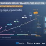
#Copernicus Sentinel-6B enters operational service today! 🛰️
Ensuring that a global sea level record begun over 30 years ago will continue into the 2030s, it will help:
🌊 Track sea-level rise
🌊 Predict storm & hurricanes
🌊 Protect coastal communities
bit.ly/4yP4mNK


EUMETSAT retweeted

#tempête #Austen #dépression
A 13h40, la dépression Austen, qui poursuit son creusement, se situait à 850 km de Ouessant où la pression atmosphérique chute. On relevait 1014 hPa ce jeudi matin, 1011 hPa en ce début d'après-midi et on prévoit 990 hPa en milieu de nuit lorsque Austen sera située sur la pointe sud-ouest de l'Angleterre (Les Cornouailles🏴).📉Une chute rapide et importante qui traduit un creusement dit "explosif".
image🛰️@eumetsat

EUMETSAT retweeted

It was exciting to join the European Organization for the Exploitation of Meteorological Satellites (EUMETSAT) @eumetsat this morning to present on a topic in their European Meteorological Training (EUMeTrain) @EUMeTrain “Event Week”.
Tropical #meteorology was the focus for the Event Week seminar series and my presentation was schedule for this morning: #Hurricane Ian: A Case for Impact-Based, Probabilistic Decision Support Services for Emergency Management and Public Safety.
EUMeTrain is EUMETSAT's largest international training project for the development of training material and training support in the field of satellite meteorology and consists of the national meteorological services of Croatia, Finland, Germany, Portugal and Hungary, led by Austria.
Agenda from the October 20-22 Event Week:
resources.eumetrain.org/even…
Event Week presentations:
eumetrain.org/event-weeks


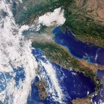
❄️ Following its 15 Sept launch #Copernicus Sentinel-3C has sent its 1st image from the SLSTR instrument!
Our Image of the Week shows a 2 Oct spring storm off the coast of East Antarctica, with spiralling cloud bands & sea ice in fine detail. Learn more: bit.ly/3U5WCsA

🚢 Journey complete for Metop-SGB1!
After crossing the Atlantic on the Canopée vessel from Bordeaux, the satellite has safely arrived in Pariacabo, the port of Kourou in French Guiana.
🎥 Discover what this next-gen mission will achieve: youtu.be/MInO4LHs92M?si=d94k…
📸 @AirbusSpace


EUMETSAT retweeted
🔴 ⚠️ 🌀 🛰️The remnants of #Isaias has evolved in an extratropical #cyclone across the Atlantic and has reached #Iceland with #hurricane winds,setting a record wind gust of 205km/h.
⬇️ 30hrs animation until early 15 of October by #MTGI Data via #Eumetview #climateemergency
EUMETSAT retweeted

🌧️ How can we better prepare for floods?
🛰️ On Disaster Risk Reduction Day, #CopernicusEU maps modelled flood depths in 🇪🇸 Iniesta, helping authorities identify vulnerable areas, assess protective measures & strengthen local resilience.
🔗 link.europa.eu/4vf93b
#ImageOfTheDay

Following today's operational launch of Meteosat-13, let's dive into the data!
This new 4D animation combines MTG sounder & imager data to map:
⚡ Clouds & lightning
🍃 Wind speed & direction
🌧️ AI rainfall estimates
🌡️ 3D temperature & humidity
Learn more bit.ly/4yiCbGY

🆕: Europe’s 1st geostationary sounder enters service today! 🛰️
The satellite - renamed as 'Meteosat-13' - will detect signs of atmospheric instability even before clouds form, helping forecasters see weather risks earlier.
Learn more: bit.ly/4zshitH
🆕: Europe’s 1st geostationary sounder enters service today! 🛰️
The satellite - renamed as 'Meteosat-13' - will detect signs of atmospheric instability even before clouds form, helping forecasters see weather risks earlier.
Learn more: bit.ly/4zshitH
EUMETSAT retweeted

September 2026 was the 2nd warmest on record globally, with temperatures exceeding 1.5°C above pre-industrial levels (Era5 Data).
#Europe saw its 3rd warmest #September, while Western part tied its record at +2.51°C (highest anomaly in #Spain with +4.6°C).
#Climateemergency
