

The Earth Observation component of the EU Space Programme
- Tweets80.7K
- Following2.1K
- Followers139K
- Likes83K






ALT An illustration of a gold-coloured satellite with extended solar panels orbiting high above the Earth in space. The curve of the blue and white Earth is visible at the bottom of the frame against a starry black background. Superimposed text reads: "Sentinel-1A. Your last mission, our new chapter." In the bottom-right corner is a white European Commission logo.

ALT This map displays the land surface temperature patterns across Belgium on June 24, 2026. The temperature data is represented using a colour gradient, with red indicating higher temperatures (above 50°C) and blue indicating lower temperatures (around 20°C). A note explains that the Land Surface Temperature (LST) is the temperature of the soil and should not be confused with air temperature. The enlarged location at the bottom left corner marks two specific points: one with a temperature of approximately 47.4°C pointing to Brussels city and another with around 24.5°C pointing to Sonian Forest right next to it. The map is produced by the Copernicus Sentinel-3 satellite, funded by the European Union.


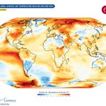
ALT The image displays a global map of sea surface temperature anomalies for June 2026. It uses color gradients where reds and yellows indicate warmer anomalies, and blues indicate cooler anomalies. Notable warm areas are the Pacific Ocean near the equator and parts of the Atlantic Ocean. Cool anomalies are visible in the Southern Ocean. The bottom of the image shows logos for the European Union, Copernicus, and other organizations.


