

WFLA-TV (Tampa Bay) Chief Meteorologist and Climate Specialist. BS Atmospheric Sciences Cornell U. MA Climate Columbia U. Past CBS News NY and Miami, Tampa, WPB
Tampa, FL
Joined November 2012
- Tweets45.1K
- Following9.6K
- Followers62.1K
- Likes83.4K







Just 10 years ago the 1.5 breach was expected in 2042.
Now: It is expected in the next couple of years. Accelerated warming.
If you are not willing do the hard work, you fail.

In 2015, the projected date for reaching 1.5°C above pre-industrial levels was 2042, based on ERA5 data. Today, our C3S global temperature-trend-monitor anticipates the threshold breach within this decade.
Read the article: climate.copernicus.eu/how-fa…
#CopernicusClimate
IDK… Sounds like perhaps we should get our act together and be grown adults… 🤔

“The high overshoot expected under current policies—with peak temperatures of about 3C–would thaw nearly all near-surface permafrost, make ‘severe and possibly abrupt’ disruption to ocean circulation likely, and lead to widespread acidification.” theguardian.com/science/2026…

🥶 COLD BLAST NEXT WEEKEND
Watch as a very amplified pattern driven by record warm blocking in Canada (like a summer heat dome) shoves and “displaces” cold air southward next weekend. That means 30s as far south as Northern #Florida and the potential for a Nor’easter! #Snow will fly for some! This Warm Canadian blocking pattern will become a hallmark of this upcoming winter, driven by the strongest #ElNino on record. #noreaster (Map animation via @burgwx PolarWx)
One of my favorite ways of putting climate change into perspective is using standard deviations. It’s too bad most folks don’t relate to it. Because, for people who understand this way of expressing likelihood, 7.22 sigma is otherworldly


“Because burning fuels to generate power, drive vehicles and heat buildings wastes much of those fuels’ energy as heat, about two-thirds of the primary energy that goes into the global system is lost before it does anything useful.”

Replacing fossil fuels may not be nearly as daunting a challenge for governments as that persistent 80%-plus share of primary #energy suggests. Because burning fuels to generate power, drive vehicles and heat buildings wastes much of those fuels’ energy as heat, about two-thirds of the primary energy that goes into the global system is lost before it does anything useful. A growing number of energy analysts point out that the energy transition does not require all that waste energy to be replaced, joule for joule, with renewable energy. Believing otherwise is what Canadian chemical engineer Paul Martin has called the “primary energy fallacy”. Or as the Oxford professor Jan Rosenow says “we don’t need to replace waste”. Rosenow is the lead author of a forthcoming study that attempts to quantify the scale of the primary energy fallacy by modelling a highly electrified global economy running on renewable power. It suggests we could get exactly the same amount of useful energy we have today with about half as much primary energy.
#climate
ft.com/content/1a40a3af-933b…


‼️ Wettest Winter on Record?!?
After our 3 Day Deluge you can understand why the US CFS model says the wettest winter on the books is possible for much of #Florida. And this does not include much of the rain Florida just received.
Super El Nino’s impacts arrived this weekend. But this is just the beginning of a very wet November through March stretch due to the strongest #elnino ever measured. The numbers are not meant to be exact, it’s just general overview. They won’t be right. They are just meant to show you how ordinary or out of the ordinary winter rain will be. And the result: unusually wet!
If you live in FL figure on a storm/ front per week on average. Sometimes more, sometimes less. It will get more active starting in December. The average of the Super Ensemble models (UK, Japan, Germany, Euro, Italy, etc…) say FL will see about a foot above normal rainfall, with some models projecting Florida will double its normal rain. It’s too early to know which part/s of Florida are favored.
The green contour on the map are rainfall anomalies, ranging from +10” to +20” in dark green.


FLORIDA’S EXTRAORDINARY DELUGE 🌧️
Wait for it…
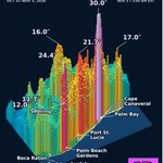
An estimated 1.88 TRILLION gallons of rain in 57 hours across the area shown—enough to cover 145,000 football fields, including end zones, 30 feet deep!
Radar estimates 30 inches near Palm Bay, with multiple torrential rainfall peaks stretching down Florida’s east coast. The radar-map area saw more than 2 dozen distinct Flash Flood Warnings, including rare #Florida Flash Flood Emergencies.
The geographic extent and repeated extreme totals make this an extraordinary, perhaps unprecedented, non-tropical #rain #flood event.
A historic El Niño favors wetter Florida weather. Today’s warmer oceans and atmosphere also increase the moisture available to fuel extreme downpours. #elnino
‼️ Flash Flood Emergency Continues
In all my year’s as a Meteorologist, I’ve NEVER seen anything like this. Multiple cities have seen 12-24” of rain, without a Tropical Storm, and it just won’t stop. ~2 feet in Palm Bay & Melbourne.
As I write this torrential bands are setting up again in Central and East #Florida dumping more #flooding rain. We’ve seen many 1-in-1000 year events in the last 2 days. Entire neighborhoods are experiencing catastrophic floods!
This is due to the Super #ElNino on top of a warmed atmosphere. With an El Niño this intense - by far the strongest we have ever seen - Expect the unexpected.

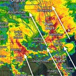
In all my years as a #Florida meteorologist I’ve NEVER seen anything like this. Several different areas have seen 1-2 feet of rain already… and it just keeps coming. This is current radar showing two training bands setting back up now. Multiple more inches of rain will fall on top of what has already fallen. Flash Flood Emergency Palm Bay and multiple Flash Flood Warnings.

This rain spike is insane.
And that’s not even the biggest in FL.


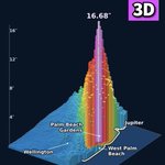
17” of rain in 6 hours in Palm Beach Gardens, almost 2X the criteria of a 1-1000 year rain event. Tragically it may have been the cause of the jet crash, as a meso low formed and concentrated 5” per hour rain rates, and lightning, with possible icing in the cloud. To be clear, this is the 3rd 1000 year rain event in the US in 3 days, amplified by Super #ElNino. A 1000 year rain event is based on historical statistics, and doesn’t mean it happens only once per 1000 years, it means there’s a 1-1000 chance any year. And in today’s warmer climate, with El Niño too, the atmospheric is now more likely to produce these rare events. #PalmBeach #Florida #Flood
17” of rain in 6 hours in Palm Beach Gardens, almost 2X the criteria of a 1-1000 year rain event. Tragically it may have been the cause of the jet crash, as a meso low formed and concentrated 5” per hour rain rates, and lightning, with possible icing in the cloud. To be clear, this is the 3rd 1000 year rain event in the US in 3 days, amplified by Super #ElNino. A 1000 year rain event is based on historical statistics, and doesn’t mean it happens only once per 1000 years, it means there’s a 1-1000 chance any year. And in today’s warmer climate, with El Niño too, the atmospheric is now more likely to produce these rare events. #PalmBeach #Florida #Flood
‼️ 1000 Year Rain Event Exceeded by almost 2X in Palm Beach Florida!
For at least the 3rd time in 3 days the US has had a 1000 year rainfall event, based on our historical climate. 17 inches in 6 hours in Palm Beach Gardens. Beats the criteria of 9” by 1.8X! Staggering. Unfortunately this storm may have very well been related to the jet accident.
I saw this rain intensity once before in Palm Beach County more than a decade ago when Delray/ Boynton had 24” in about 6 hours. Closed I-95.
A 1000 year event means the historic statistical chance is 1-in-1000 each year or .1% - it does not mean it happens only one per 1000 years and now-a-days because of our warmer climate and this year because of Super El Niño it’s a lot more possible because there’s now more moisture in the atmosphere. With #ElNino expect the unexpected!!


It’s true. There was a time both the left and right accepted the science and understood the serious threat.

I’d like to mention Mrs Thatcher warning about man-made climate change being a threat as big as nuclear war, not because I’m a fan of Mrs Thatcher, I can’t stand her, but I think it’s important that people on the right understand that climate change is not a left-wing conspiracy even though the fossil fuel propaganda says exactly that
Ok that brings back nightmares

For a meteorologist, ghosts and goblins are not the scariest thing, and neither are bats or monsters. It is the Quasi-Geostrophic Omega (QG Omega) equation. Yet we all successfully managed to break these down to read the atmosphere.
Meteorologists are scientists. #Halloween


Earth has never had a month that exceeded +2C above pre-industrial. But that may change by winter. 1/2 of the Super Ensemble members forecast a +2C month - the average says we reached +2C is February. BOM is the highest at +2.33C.
This breach of 2C is due to global warming, with the Super El Niño heat added on top, and yes the change in aerosols/ cloud cover/ sun reflectivity.
The #ElNino will peak in ~December, but peak Global temperature lags El Niño by a couple of months as stored ocean heat is released.
The breach of 2C will be temporary, as El Niño fades the global temp will drop back down… but likely not back to where we were before. It is in this way that El Niño sets a new bar, and another “stepped” increase in global temperature. There’s no sign yet that carbon fueled march upward will stop anytime soon.
