

I am a Believer in Christ | California State Weather | CA + NV/UT/AZ | CA always first
- Tweets1.3K
- Following443
- Followers812
- Likes3K


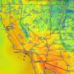


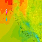


ALT The two images shows the probability of snow amounts in the first storm this weekend. China Peak has a 25 percent chance of 8 inches, Tioga Pass has a 78 percent chance of 12 inches of snow, and Mammoth Peak has a 53 percent chance of 12 inches of snow.


ALT Graphic showing a large breaking wave on the left and details on the right.


ALT A Beach Hazards Statement remains in effect now through 6 PM Friday when it will be replaced with a High Surf Warning from 6 PM Friday to 4 AM Sunday. Breaking waves of 15 to 20 feet are expected for the duration of the Beach Hazards Statement.

ALT Graphic highlights a pattern change expected with above normal precipitation favored across much of the Western US. Uncertainties are described which include unknown timing details and potential for snow in the higher elevations.


ALT An information graphic from the National Weather Service Salt Lake City, UT titled "WE’RE ABOVE AVERAGE!" with the subheadline "Highs Averaging 5°F Above Seasonal Normals Once Again". The background shows a light blue sky with a cartoon illustration of a smiling sun wearing a red and yellow winter scarf. Key Forecast Message:Another dry, mild day is ahead for Utah and southwest Wyoming, with highs around 5°F above normal. Similar conditions continue through Friday before a storm system potentially brings changes this weekend. Tuesday Afternoon Highs Map (November 10, 2026):Saint George / Zion NP: 69°F / 74°F Salt Lake City / Tooele: 59°F / 57°F Ogden / Brigham City / Logan: 57°F / 58°F / 58°F Provo / Nephi / Delta: 61°F / 60°F / 58°F Richfield / Cedar City / Milford: 61°F / 61°F / 60°F Evanston / Randolph: 54°F / 55°F Price / Vernal / Duchesne: 59°F / 56°F / 57°F Moab / Bullfrog / Kanab: 59°F / 63°F / 66°F Footer: Issued 11/10/2026 5:48 AM MST. NWS Salt Lake City,


ALT Coastal Flood and High Surf Hazards continue into Tuesday

ALT Photo of debris after the Woolsey Fire in 2018.

ALT Photo of debris after the Woolsey Fire in 2018.

ALT Photo of debris after the Woolsey Fire in 2018.

ALT Photo of structures burning during the Woolsey Fire in 2018.

ALT A potential shift to an active weather pattern remains forecast late week into next weekend. While timing uncertainty remains, heavy rain, heavy mountain snow, and gusty winds will be possible when the pattern shift arrives.

ALT High surf with dangerous rip currents and coastal flooding issues will occur tonight into next week.

ALT Winterize your home. Inspect your chimney. Caulk and weather strip doors/windows. Insulate exposed pipes. Insulate your attic. Clean out gutters. Install and test smoke alarms and carbon monoxide detectors (with battery backups). Gather supplies.


ALT Red Flag Warnings in effect on Saturday


ALT Potential atmospheric river activity could bring enhanced moisture to much of the West Coast during mid-November. There is increased uncertainty regarding the potential for heavy precipitation. Strong surface low pressure north of the region will also likely drive high winds along the immediate coastline. Moderate risk (40 to 60%) of heavy precipitation shown for Nov 13 to 15 across parts of the Pacific Northwest and northern/central California, with slight risk (20 to 40%) extends to Nov 17 across the West Coast into the Desert Southwest, Great Basin, and Southern Rockies. High winds are possible across much of the West, including a moderate risk along the immediate West Coast Nov 13 to 15 and broader slight risk to Nov 17. Moderate risk of heavy snow across the higher elevations of the Klamath and Sierra Nevada Nov 13 to 15. Slight risks of heavy snow extend to Nov 17 for these areas as well as the Northern Intermountain, Great Basin, and Central and Northern Rockies.

ALT Hazardous beach conditions will be present at Pacific Coast beaches 5 AM Thursday through 7 PM Saturday as long period northwesterly swell brings breaking waves of 12 to 16 feet, along with an increased risk for sneaker waves and strong rip currents. Waves can sweep across the shoreline without warning, pulling people into the sea from beaches, jetties, and rocks. Stay off of jetties, piers, rocks, and other waterside infrastructure, remain out of the water to avoid hazardous surf, and never turn your back on the ocean!